Mapwork:
Latitude and longitude
 |
| latitude (with degrees) |
Latitude:
 |
| latitude |
Definition of latitude:
the angular distance of a place north or south of the earth's equator, or of the equator of a celestial object, usually expressed in degrees and minutes.n geography, latitude is a geographic coordinate that specifies the north–south position of a point on the Earth's surface. Latitude is an angle (defined below) which ranges from 0° at the Equator to 90° (North or South) at the poles. Lines of constant latitude, or parallels, run east–west as circles parallel to the equator. Latitude is used together with longitude to specify the precise location of features on the surface of the Earth.
Longitude:
 |
| longitude |
Definition of longitude:
Longitude (shown as a vertical line) is the angular distance, in degrees, minutes, and seconds, of a point east or west of the Prime (Greenwich) Meridian. Lines of longitude are often referred to as meridians.
 |
| longitude (with degrees) |
Natural Disasters

Definition: A natural disaster is the consequence of the combination of a natural hazard (a physical event like a volcanic eruption,typhoon, tropical cyclone tornado, an earthquake, a landslide or a tsunami) and human activities.
Most natural disasters are caused by weather.

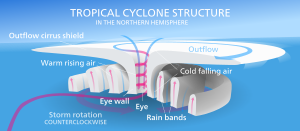
- hurricane, can be predicted, it is a tropical cyclone.
- tornados ,
- floods, most expensive type of natural disaster
- tsunamis,
- thunderstorms
- wind storms,
- wildfire, caused by lightning or by people
- avalanches, and
- blizzards, can be predicted
- volcanoes and
- Earthquakes, deadliest of all natural disasters.
- Some of the weather disasters can be predicted such as hurricanes and blizzards. The technology is getting better in predicting tornadoes and severe thunderstorms. By getting the data early people can be warned to take shelter or make the necessary preparations.
- Some natural disasters are caused by volcanoes and earthquakes.
- Some wildfires are caused by lightning, but some are caused by people
- Flooding is the world's most expensive type of natural disaster because the damage can be extensive
- Earthquakes are the deadliest of all natural disasters
- Some kinds of disasters are more common in some places then in others when people are choosing a place to live they need to consider whether they will live on a fault line for an earthquake or near a river that has a history of flooding.
- There isn't any way to avoid natural disasters but if people know what kinds of disasters are most likely where they live they can learn what to do if a disaster happens in order to stay safe
- Many different agencies such as the red cross and red crescent come to the assistant of people affected by natural disasters.
Hurricane, can be predicted, it is a tropical cyclone.


- Large movements cause the waves to be formed, making waves.
- These waves travel across the ocean to affect distant lands, at great speed (500 miles per hour). Wonder if your car can drive this fast. Not, me thinks.
- When the waves approach the shallow waters they pile up and grow in height. Monstrously terrorising the poor beach goers, and old folks.
- At the coastline - the trough pulls the water back, and these crest of the wave grows higher and higher, ready to smack the shore. Please don't play in the receding waters, you may be smacked by the growing 300 meter crest. Good to pray before this happens, it may be the last thing you do.
- Japan is not popular because of its frequent Tsunamis. Nice people though. Love to JAPAN. Pacific Ocean. Indian Ocean Tsunami of 2004 killed 230000 people. That really ruined alot of Christmas holidays.
- Tsunamis can cause major damage, like a city being hit by a really big bus.
- Early warning systems for Tsunamis help people get to higher ground. I think these discriminate against people with hearing impairments.
Earthquakes, deadliest of all natural disasters.
Definition of Earthquakes: a sudden violent shaking of the ground, typically causing great destruction, as a result of movements within the earth's crust or volcanic action.
The rapid release energy is released from the earths crust, causes seismic waves that travel through the earth.
facts on earthquakes:
- Earthquakes involve the powerful movement of rocks in the Earth’s crust. The rapid release of energy creates seismic waves that travel through the earth.
- Scientists use the different speeds of seismic waves to locate the epicentre (the point on the surface directly above where the earthquake originated) of earthquakes.
- Seismometers are used to measure the magnitude of earthquakes. You are unlikely to feel a magnitude 3 earthquake but a magnitude 6 earthquake could potentially cause large damage.
- The damage caused by earthquakes also depends on their depth and fault type.
- The earthquake that hit the Tohoku region of Japan on March 11, 2011, had a magnitude of 9.0 and killed over 15000 people.
- The destruction caused by the Tohoku earthquake was made much worse by powerful tsunamis that were triggered due to the earthquake’s epicentre being located offshore. More tsunami facts.
- The 2004 earthquake that occurred in the Indian Ocean near Sumatra, Indonesia triggered a series of tsunamis that killed over 200000 people in 14 countries.
- The February 2011 earthquake in Christchurch, New Zealand followed nearly 6 months after a magnitude 7.1 earthquake shook the region. The earthquake killed 181 people and significantly damaged the central city. The economic damage caused by the earthquake and aftershocks is estimated to be around $15 billion (NZ$).
- An earthquake that hit Haiti in January 2010 with a magnitude of 7.0 killed over 200000 people according to Haitian sources.
- The most powerful earthquake ever recorded on Earth was in Valdivia, Chile. Occurring in 1960, it had a magnitude of 9.5.
- It is important in earthquake prone countries such as Japan to build houses and buildings that react well to earthquakes. Good engineering practises can help stop buildings collapsing under the stress of large earthquakes.
how does it occur:
Earthquakes are usually caused when rock underground suddenly breaks along a fault. This sudden release of energy causes the seismic waves that make the ground shake. When two blocks of rock or two plates are rubbing against each other, they stick a little. They don't just slide smoothly; the rocks catch on each other. The rocks are still pushing against each other, but not moving. After a while, the rocks break because of all the pressure that's built up. When the rocks break, the earthquake occurs. During the earthquake and afterward, the plates or blocks of rock start moving, and they continue to move until they get stuck again. The spot underground where the rock breaks is called the focus of the earthquake. The place right above the focus (on top of the ground) is called the epicenter of the earthquake.
Population Densicty
Definition Population Density:
Definition Population Density:
Population density is a measurement of population per unit area or unit volume. Population density refers to the number of people who live in a certain area. This can tell you how crowded the area is.
It is frequently applied to living organisms and most of the time to humans. Population
Density is a key geographical term.
Human population density


For humans, population density is the number of people per unit of area, usually quoted per square kilometer or square mile (which may include or exclude, for example, areas of water or glaciers). Commonly this may be calculated for a county, city, country, another territory, or the entire world.
How to workout population of an area?
divided by the total area is sq km (km2).
For example
to calculate the population density of the western cape which has a population of 6,016,900 and an area of 129,462 km2:
=6,016,900 ÷ 129,462 = 46,476
so the western cape has a population density of approximately 46 people per km2
Population of South Africa's provinces
Since the election of 27 April 1994, South Africa has been divided into nine provinces. They vary widely in population, from the mostly-urban Gauteng, which contains over 20% of the national population, to the mostly-desert Northern Cape, which contains less than 3%. The following table shows the provincial populations according to the 2011 National Census[1] and the most recent mid-year population estimate by Statistics South Africa.[2]
| Rank | Province | 2011 census | 2015 mid-year estimate | ||
|---|---|---|---|---|---|
| Population | Percentage | Population | Percentage | ||
| 1 | Gauteng | 12,272,263 | 23.7 | 13,200,300 | 24.0 |
| 2 | KwaZulu-Natal | 10,267,300 | 19.8 | 10,919,100 | 19.9 |
| 3 | Eastern Cape | 6,562,053 | 12.7 | 6,916,200 | 12.6 |
| 4 | Western Cape | 5,822,734 | 11.2 | 6,200,100 | 11.3 |
| 5 | Limpopo | 5,404,868 | 10.4 | 5,726,800 | 10.4 |
| 6 | Mpumalanga | 4,039,939 | 7.8 | 4,283,900 | 7.8 |
| 7 | North West | 3,509,953 | 6.8 | 3,707,100 | 6.7 |
| 8 | Free State | 2,745,590 | 5.3 | 2,817,900 | 5.1 |
| 9 | Northern Cape | 1,145,861 | 2.2 | 1,185,600 | 2.2 |
| South Africa | 51,770,561 | 100.0 | 54,956,900 | 100.0 | |
Migration is the movement of people from one permanent home to another. This movement changes the population of a place. International migration is the movement from one country to another. People who leave their country are said to emigrate. People who move into another country are called immigrants.
Population growth
In biology, population growth is the increase in the number of individuals in a population.
why people live where they do?
Natural factors:
- Climate - pleasant temperatures, humidity, rainfall,
- Relief - the height and the shape of the land
- Resources - basic needs of food and water, fertile areas to grow crops,
Human factors:
- Economy - earn money, jobs
- Political decisions -
Urban and rural settlements:
- Urbanization: People migrate for economic and political reasons.
Urbanization


- Urbanization is a population shift from rural to urban areas, "the gradual increase in the proportion of people living in urban areas", and the ways in which each society adapts to the change
- More than half the population of South Africans has become urbanized. South Africa is one of the most urbanized
The Seasons
- The earth rotates once every 24 hours on its imaginary axis
- The earth axis os always tilted at the same angle.
- This rotation causes day and night
- The earth revolves around the sun
- This path is called orbit.
- The sun does not move it stays in one position.
- The earth takes 365 1/4 days to revolve around the sun.
- The revolution of the earth causes seasons
Summer and winter days
summer in the southern hemisphere:
- summer solstice sun's rays fall directly over the tropic of Capricorn -22 December
- the southern hemisphere is tilted towards the sun
- the southern hemisphere has summer
- experience long days and short nights
- south pole has 24 hours of daylight.
Winter in the southern hemisphere :
Winter Solstice:
- the sun's rays fall directly over the tropic of cancer-21 June (winter solstice the southern hemisphere is tilted away from the sun
- the southern hemisphere has winter experience short days and long nights
- south pole has a 24 hour night
Autumn And Spring In The Southern Hemisphere:
- the sun's rays fall directly over the equator -21 march
- neither hemisphere is tilted towards the sun
- the southern hemisphere has autumn
- all places on the earth have a 12 hour day and night
- 21 march -autumn equinox
Spring In The Southern Hemisphere:
- the sun's rays fall directly over the equator- 23 September
- neither hemisphere is tilted towards the sun
- the southern hemisphere has spring
- all places on earth have a 12 hour day and night
- 21 march- Autumn Equinox
Weather:
the state of the atmosphere at a particular place and time as regards heat, cloudiness, dryness, sunshine, wind, rain, etc.
Climate:
he weather conditions prevailing in an area in general or over a long period.weather maps:
a map showing the state of the weather over a large area
Climate maps
Climate maps. give general information about the climate and precipitation (rain and snow) of a region. Cartographers, or mapmakers, use colors to show different climate or precipitation zones. Economic or resource maps.